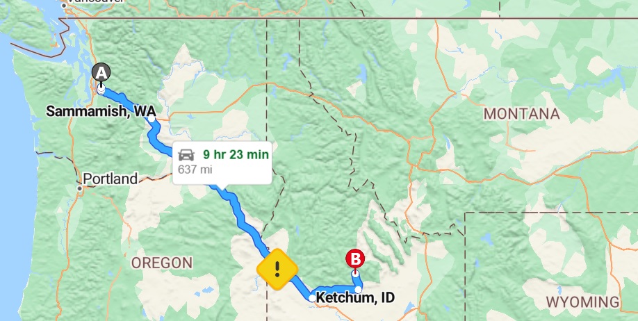
Its 12:30 pm on Tuesday, June 24th, 2003, having just left John and Beth’s house in Sammamish and now heading on 90 East. The goal today is Ketchum, Idaho to visit Hemingway’s Ghost, the place where he took his life with a shotgun and is buried.
I enter Mt. Baker, Snoqualmie State Park, and I keep climbing upwards. The scenery is stunning. I can see snow in the mountains, as well as ski trails, and the Passat labors for 60 mph. The cars are sparse out here and it’s hot.
I should comment on my new cell phone. John let me borrow one, even though I vehemently protested. For years I’ve enjoyed being one of only seven people in Hollywood who doesn’t own a cell phone. But John and Beth both insisted, and I’ll take that as an omen to do The Safe Thing.
The mountains recede further back, and open land stretches out to my left after the trees. We continue heading down and my ears are popping, and I see the little squiggle trails of snow on the mountains.
And now climbing again on a road that is bumpy. Just saw a sign for Stampede Pass, Lake Kachess. I started the day again with no coffee. I guess we are all doomed to repeat the past.
And what’s this white stuff floating at me?
Is it cotton? It looks like snow, but in this weather impossible unless I’m in some sort of twilight zone. It’s either cotton or big chunks of pollen. The John Wayne Trail is exit 71, and the wind rips off the Yakima River with my ears popping. Passing a steel girder bridge which breaches the Cle Elum River.
A note on my food situation.
Beth made me a turkey sandwich (how nice was that!), and there’s still some Cape Cod Firecracker BBQ chips that I bought in LA. There’s also still a few bites of a muffin, but I don’t know where it is now . . . probably on the floor. I don’t particularly want a floor muffin.
The sky cleared after passing the hills, and it’s now just one all-encompassing wide-open space, what I picture Montana to be. A lot of clouds, the stretched-out kind of clouds, and a few trees with extended land.
My allergies are about to open a can of whoop-ass on me, and it must be pollen in the air because I just sneezed. Whatever it is, it looks like big puffy snowflakes. Coming up to 82, with Yakima one mile east, and that’s what I’m taking. I’ve lost sight of the river and it’s very flat.
There’s a Military Area at Exit 11, but you can’t see anything of interest. Is it underground or invisible or did it shut down? My mind has fun and thinks something clandestine is going on here, like alien autopsies that Mulder and Scully would be investigating. But I guess if it was truly top secret, it wouldn’t be marked a military area with its own exit.
Or would it?
At elevation 2,315 feet, Umtanum Ridge, the clouds are casting long shadows on the rolling hills to my right and left. I head into a valley, Burbank Creek, but soon ascend again, entering Yakima County. There’s a funky smell out here, but no cows or any sort of animals to justify it. Only rocks, hills, shrubbery.
I go down for the next three miles into Apple Valley. I don’t see any apples, but the car cuts through a rocky ridge. Curving to the right, there’s an expanse of a town to share in this heat and wind. A sign warns “Caution, Severe Side-Winds”, and yes, there is.
It’s now 2:26 pm and it’s 77 degrees from that bank sign. Seems much warmer. Lot of cut logs on the right, all the trees cleared out. “Welcome to Yakima, The Palm Springs of Washington” . . . what the hell does that mean?
Can see a Target and an Office Max, Pier One Imports. You got your BK, Taco Bell, Best Western, Quality Inn, Shell station, your Gear Jammer Truck Plaza, exit 36 Union Gap, Lowes, Denny’s. I think of the Talking Heads song “Nothing But Flowers”. Not exactly living up to that Palm Springs boast.
Slowing up, a lot of cotton in the air, and I’m coming to a complete stop at Mile 38. Once again it looks like it’s snowing. It’s an accident, and I see a pick-up truck’s crushed windshield, along with fire trucks, cops, and three other cars involved. There’s an ambulance and the Yakima 29 News van has made the scene. There’s another car on the other side of the road, smashed, and a reporter lugs a camera toward it. I guess a car wreck makes big news out here. I hope there were no serious injuries.
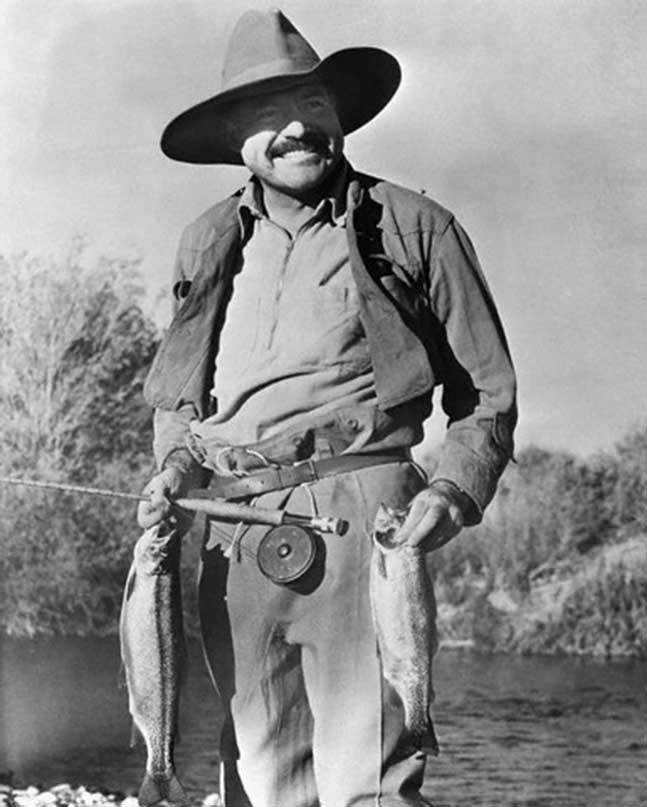
The river seems like one that you’d like to white-water raft down. Now we got round rolling hills like elephant skin on my left, some green fields on my right, and a lot more trees than before. Perfect Hemingway country.
I’m going to see my favorite writer, but unfortunately, it’s only to visit his gravesite.
Where once there was bullfighting, booze, dames, and danger, there are bones somewhere under the ground in Ketchum, Idaho. But no need to get morose, as it’s Hem’s spirit which has brought me out here and my respect for him and for the life he lived. I am excited.
Exit 44 is Wapato, and the cars have thinned out up here. Teapot Dome Service station is the next right, and there’s a sign that says this is a historic site. Probably not the gas station, but the area due to, I’m guessing, the Teapot Dome Scandal. I try to recall my high school history, but my brain rattles about without conjuring up the events.
(2023 note- it had nothing to do with the Teapot Dome Scandal! I looked it up after all these years and it’s a gas station shaped like a teapot, a genuine old school roadside attraction. I wish I had stopped!)
Port of Sunnyside is coming up, with signs for tourist activities. There are cows and a blown tire in the road, but I can’t see a port or any activities. Another tourist activities sign . . . what the hell they’re talking about? There’s nothing out here!
Now I’m climbing up into those brown, rolling hills with the clouds throwing shadows. If I stick my hand out the window, and cup my hand, I can create a sort of blast of air on me. Cools me down a little, but it’s mostly an illusion because the air is oppressively hot. I should have gotten the AC fixed, though of course I could not have afforded to do so.
Too windy with the windows rolled down, but rolled up creates a greenhouse effect in my Passat. I snake down into a valley, and the first exit I’ve seen in a while is called Coffin Road. What kind of sick bastard names a street after that?

Why am I crossing back into Oregon?
For all that’s good and holy, I hope I’m going the right way. Traveling over some water right now, a big suspension bridge over the Umatilla River. This is what happens when you don’t look at a map.
To be accurate I briefly looked at a map from John’s computer this morning, but foolishly didn’t print anything out. And of course, I have all the map books from AAA that I haven’t even cracked open, lying in a bag in the back seat.
If I was with somebody else and we had someplace we had to be, I would have done more mapping/planning. I did on that 1998 trip (my first cross-country adventure) when I drove from Boston all the way to LA with Anastasia. But I am alone, and I don’t care.
I’m on the 84 East, which I want, but why did I just see a sign for Portland?
I can’t even consider the fact that I’ve made a mistake. Even though I am on a very loose timetable, it would send me screaming on the side of this road if I’m going the wrong way. It’s 4:15 pm and the land is flat, a sea of yellow grass.
The State Police of Walla, Walla is the next right and I’m entering Umatilla Indian Reservation. Drew Bledsoe is from Walla Walla, and even though it was Tom Brady (and Bill Belichick) who brought us our first Superbowl, it was Mr. Bledsoe along with Mr. Kraft and Bill Parcells, that brought the Patriots franchise out of the depths of mediocrity into the winner’s circle. I tip an imaginary cap to Drew.
The big puffy clouds have returned, and as I look at the 2nd hitchhiker I’ve seen on the road, I wonder if I’ll pick one up on this trip. Hitching was an American institution, and it conjures up images of Jack Kerouac and Neal Cassidy and the romance of that time. But my generation was brought up to think every person sticking out a thumb on the side of the road was an ax-wielding maniac who wanted to chop you up and steal your car.

At 5:15 pm I see my first sign for Boise.
I spot a little creek, and dream about sticking my head into it. Not many cars out here, but there’s some good road work and only one lane curving up the mountain.
Up ahead there’s some mountains with snow, and Wallowa Lake is the next right. The snow sparkles on the mountain range ridge on my right as I pass a prairie. Now heading into another forest, hills clinging to the road, with tall trees. Navigating up this curve, exit 270, with lot of construction and one lane. They’re laying tar and it smells.
A sign declares I’m halfway between the equator and the North Pole, the 44th Parallel. I know that should seem cool to me, but after driving all day, I just can’t even compute what it means.
Am I in Idaho? Was the 44th Parallel Idaho, or another dimension?
I haven’t seen a sign to say I’ve crossed, and damn do I like to see those signs. Can still see the mountain range on my right, to my left rolling hills with the chia stuff on them and some more cows.
I spot signs for the Oregon Trail Interpretive Center and think of how all those crazy bastards crossed the country back then in a wagon. But I take the next exit at Baker, established in 1874, and we have the General York Store, Oregon Trail Museum (which is closed), and Ye Olde Rite Aide. I go into the pharmacy, buy some cassette tapes for the verbal notebook, a couple of pre-made sandwiches, a Gatorade, ice for the cooler, a coffee, and gas up $22 worth.
I’ve been heading southeast to get down into the Sun Valley area in Idaho, going far, far out of my way for Mr. Hemingway. Then again, what exactly is my way? No clue, and I note the 3rd speed trap I’ve passed.
Smokey couldn’t get me because I was barely five miles over the speed limit. And there’s the simple secret to driving cross country: go with traffic, don’t pass, and if you’re all alone stay within five miles of the limit. But it also helps to be driving a beat-up, piece of shit car.
I enter the Mountain Time Zone at 7:36 pm, but the Time Gods now say it is now 8:36 pm. On my right is a rocky slope and I climb up, struggle, and climb some more. There’s a bunched-up cloud collection ahead that almost looks like a giant spaceship. Blue sky, setting sun, some cows, and I’ve finally reached the top of these mountains. I begin to descend into that enormous cloud formation, but two miles later I go back up again.
It’s almost 9 pm and the disappearing sun is casting a long shadow in front of the car. Miles away and on my left, it almost looks like a mini–Grand Canyon. I’d love to explore it. The car shadow is on the left now, and it looks like the batteries for the radio are going the way of the sun. There’s a Correctional Institution next right, and I’m still far from Ketchum.
Nobody in front or behind, and I come down in elevation.
Passing the Malheur River, I must be close to Idaho, and I spot another hitchhiker. There’s a Motel 6 for $36 a night . . . should I stop? I don’t, but note the gas station is selling $1.55 unleaded, the cheapest I’ve seen. It’s 74 degrees and the sun is behind me and on my right. 57 miles to Boise and the road sign says “Oregon thanks you, please come again”.
I zoom into Idaho, but I don’t see an official welcoming sign. I pass Hells Canyon Recreation Area, New Plymouth, and Fruitland, all declaring they are in Idaho. Idaho is my 3rd new state on this trip, and a fine one thus far with a speed limit of 75. Why didn’t Idaho welcome me?
It’s quite windy, and the clinging sun casts a car shadow in the left center of the road. There’s are no other vehicles out here except for a foreboding tow truck that just passed me. If I broke down here, I would be eating the floor muffin. The cell phone still says it’s searching for a signal.
I’m about 60 miles away from that Highway 20 turnoff, and another 90 miles to Ketchum. The hotels in Sun Valley, it being a ski resort area, are probably more expensive. But maybe since it’s summer I’ll get an off-season discount. I must spend the night in the same town where Hemingway once lived and eventually died.
I’m not tired, although it’s been about eight hours of driving (or maybe nine since I had the time change), and I am probably good for two more. The sun is casting an amber color to the farm on my right, still not quite down yet. The light clings to the horizon behind, and it’s getting dark as I cross the Boise River. The orange glow of the sun reflects in all my mirrors as I come up to Caldwell Airport.
There’s a sign for Twin Falls and the sun radiates a yellow-orange shine against the billboards. There are some hotels at exit 35 in Nampa, and the gas station sign gives the temperature of 71 degrees.
Straight ahead there are mountains, about 100 miles or so in the distance. I pass the Warhawk WW2 Air Museum, which is exit 38, and an electric sign flashes “The Lord will deliver in times of trouble”. You gotta love highway evangelism.
A lot of people exit in Nampa as the periwinkle blue sky announces dusk. It smells like manure at the Meridian city limits, population 34,919. Pinkish, elongated clouds catch my attention in the sideview mirror. More cars enter the fray as we’re closing on Boise.
I’m approaching those mountains and the sky grows darker as I finally drive into Boise. At ten o’clock I stop at a rest area, with a sign giving some information about the Oregon Trail and Native Americans. I look in my plastic AAA bag for the first time.
The lady in the AAA Glendale Office would be livid. You want all this information now? she said with such disdain when I asked for the trip books for this journey. But she gets her revenge because there isn’t one for Idaho. I yearn for some lodging suggestions, but I’m shit out of luck.
I continue toward Route 20, which will bring me into Sun Valley. Ahead is pure darkness, but in the rearview there’s still some glow. It’s flat on either side, and the clouds are dark gray, mixed in with the blue sky. Beautiful.
But I do not like driving with my glasses on at night, especially with these game crossing signs. There’s a bit of fog here, and the possibility of a tornado enters my mind. Visibility is poor and I haven’t seen an exit in a long time. The wind is pushing the car around.
I want exit 95, which is still probably not close because the exits come slow, if at all. With all these trucks I’m really looking forward to that country road. I see a billboard for the Casino Getaway Resort. Should I stop there? A few hours of poker and a good night’s rest? But what if I hit a cold run of cards and blow all my travel money?
I continue east and somehow Exit 95 is only one mile away. What happened to exits 91-94? I’m looking for a hotel. There’s a Best Western here . . . should I try it or not? This is Mountain Home city limit, and I’m still determined to get to Ketchum.
I’m 111 miles to Sun Valley from and it’s 10:40 pm.
I’m not tired, and what’s a hundred or so miles after all the ones I’ve traveled today? But it’s dark, I’m wearing glasses, and this is a 2-lane road (one for each direction). I switch on my high beams for the first time.
Nobody in front, nobody behind, and I’m careening down Route 20 toward Sun Valley. I’m passed the clichéd point of no return, and it’s going to take at least two hours to get there. I see myself in a SNL Bad Idea Jeans commercial. But if for some bizarre reason a hotel appears, I will stop.
Seems barren out here, the clouds resemble splotches of ash or soot. I’m only driving 60, and the speed limit is 65. Cow crossing, open range, and I’m still climbing, and the Passat hates it. Finally a car passes me and I watch the taillights go up and down and up and down.
I can make out some mountains on my left, but they are silhouetted and barely discernable. In my rearview there is nothing now, just a black void, as dark as I’ve ever experienced. The road is narrowing even more, and the intense wind is making it even harder to drive.
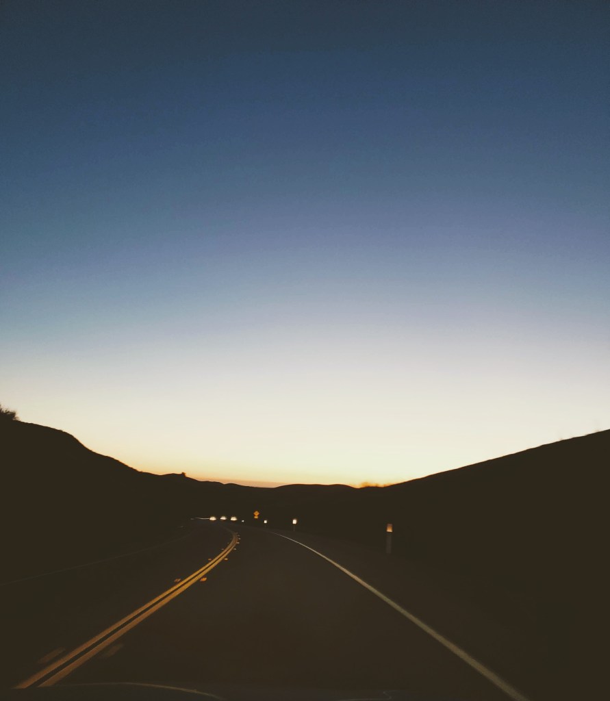
I continue on and it keeps getting darker. It’s nice there’s nobody on this road, but with my poor night vision and dearth of lighting, I could drive into a ditch or ravine without any provocation. I should have stopped when I could have found a hotel.
There are no hotels and the road is becoming twisty and curvy. Sun Valley is 87 miles away, and Hill City is 21. If there’s any places to stay in Hill City I’ll stop.
But the stars . . . wow! Just from looking out my window at 60 mph I can see an intergalactic planetary show.
Climbing again, and it’s steep. The car struggles for 50 as I approach a scenic overlook ahead that is just blackness to me. I’m at 5,527 ft elevation in Sawtooth National Forest, and I’ll have to come back this way in the daytime. Haven’t seen a car in a long time, except that parked one where the driver was likely snoozing. Hope I don’t have to do that.
Something just passed over the road, hopping along at a fast clip, and it looked like a miniature kangaroo. Has to be a jackrabbit. I see my first set of lights in my rearview mirror, ones that are far away. Game crossing next 9 miles as the clock nears 11 pm.
Bugs hurl themselves at my windshield, and I should not be driving now.
But at least I have plenty of gas. I finally enter Hill City, and there isn’t going to be any lodging despite the Visitor Info sign. For some consolation, at least my eyes have somewhat adjusted to the blackness as we’re fifteen minutes to midnight.
There’s a market and the Elk Ridge Mountain Inn, but both are likely closed. I drive around the Inn, get out, look inside the office, and laugh (insanely, maybe?) at the fact that nobody is there. There’s a billboard for a Best Western, but that’s in Sun Valley and 48 miles away. I press on, and more cars appear, which basically translates into more assholes who don’t switch off their high beams.
I see a green light ahead, one I’ve been glimpsing for a few miles now. Maybe it’s Gatsby’s Green Light, “boats against the current, borne back ceaselessly into the past.” It could very well be, Old Sport.
My eyes are going screwy.
That light wasn’t green, just a normal white light on the left side of the road. Weariness has saturated my body to the core. I pass Big Wood River and roll up the window because I’m getting cold. There’s a Rest area one mile ahead, and a stop sign coming up. I’m at Junction 75 and I take a left.
Sun Valley is 26 miles and I’ve forsaken that rest area because I desperately ache for a hotel. Slowing down to 35 mph at 12:30 pm in a little town called Bellevue, I pass a gas station and a saloon that are both closed.
It’s 17 miles to Sun Valley, and I say a prayer to the Hotel Gods that there’s a room for me somewhere, anywhere. Entering Hailey, population 6,200, and the Hitchcock Motel could be my savior. But there are no lights on anywhere. I would happily stay at the Bates Motel now without thinking twice.
A hitchhiker looks my way and I imagine him to be crazy.
He’ll steal my car, leave me on this stinking Idaho backroad, and go on a crime spree using my vehicle, money, and ID. That is if he doesn’t kill me first. These last 11 miles are going to be tough. I pass Big Wood River, go up one more hill, and please let me be in Ketchum. Another jackrabbit plays chicken with my car and wins.
Here is Ketchum!
Where is that Best Western? How in the hell can I be longing for a Best Western? There it is, and there’s the dreaded “no vacancy” sign. I drive up and down the streets of Ketchum, finding nothing but residential housing.
I need to find a place to park and sleep.
There’s a hospital, but I’m sure I’ll get rousted in the parking lot at night by the security guards. I see a sign for a picnic area and drive onto a dirt road. I get out, stretch my legs and arms, and the river here is quite soothing. This could be a great place to sleep. The stars are so bright and make it possible to see the rushing water.
What about that hitchhiker?
He was far away, but probably could make it here in three or four hours. It’s irrational, I know, but I should be somewhere where there’s at least some people. Didn’t Michael Jordan’s Dad get killed sleeping in his car? I’m going to drive all the way back to that rest stop, park next to a truck, crack the windows, and try to get some rest.

Oh wow! You are braver than I. (Although I HAVE been to the Teapot Gas Station a few weeks back.) You drove back to the rest stop? Oh you poor boy. Anxious to find out what happens next. Cheers!
LikeLiked by 1 person
That was a crazy night! I really wanted to spend the night in my car by that river, and I’m sure it would have been nice to wake up there. But yes, I drove all the way back to the rest stop, and then the next morning I drove all the way back into Ketchum. 🤦♂️
LikeLike