
I spent the night at the Big Timber Super 8 Motel in Montana, struggling through an incongruous sleep that didn’t result in much rapid eye movement. Driving out of the parking lot in the morning I see a sign telling me the Big Timber Rodeo is tonight and tomorrow . . . but I won’t be here. Lucky Lil’s Casino Country Skillet might be a good place to get breakfast, but it’s a little after 10 am, and I’m an hour behind schedule.
I gaze at the Crazy Mountains, rising grandly behind me as I head east on the 90. An unknown mountain range, inundated with snow, appears on my right in the distance. There’s a few puffy clouds by the Crazies, but mostly the sky is just thin smears of white into the blue.
This road is a straight shot of flat asphalt with hardly any cars, and I should be able to eat up a lot of miles if it continues like this. The snow-covered mountains are still on my right, I curve to the left to skirt them. The Crazies still glimmer in my rear and side-view mirrors, but I won’t be able to see them again after I’ve gone around this bend.
Entering the county of Stillwater I start singing “Fever Dog”, the song by Cameron Crowe’s fictitious band of the same name. The wind is still whipping, and I can’t help but think of tornadoes. Once again I see The Yellowstone River.

After I reach Billings I get onto the 212 highway, and from the map it should take me into Mt. Rushmore. I plug in JP’s cellphone as I go up this hill, but I’m getting no reception. It did work briefly the other day and I made one call to my brother and received one from John, but overall it’s been as useful on this journey as an abacus.
The Bear Tooth Mountain Range is on my right as I zoom along at 90 mph with my windows shaking. I slow down to 85 and it’s much quieter, the elderly Passat Wagon wasn’t built for speed. There’s a river running on my right and big stacks of hay spread across the land on both sides. Cows and a couple dogs lollygag close to the road.
I spy two interesting billboards. The first, a message clearly for locals: “Will Cattlemen Open This Plant?” (not sure what it means). And the other for the “C’Mon Inn” . . . would have stayed there if I had made it this far last night.
Billings has faded, and a guy in a bright pink shirt is hitchhiking. I can’t imagine the color pink is popular with ranchers. An odious stench has seeped into the car, and I bet it’s that industrial plant on my left. This is the dung from chemicals, not cows. Pictograph Cave is at exit 452, but if that isn’t your style you can try your luck at the Little Big Horn Casino, exit 510.
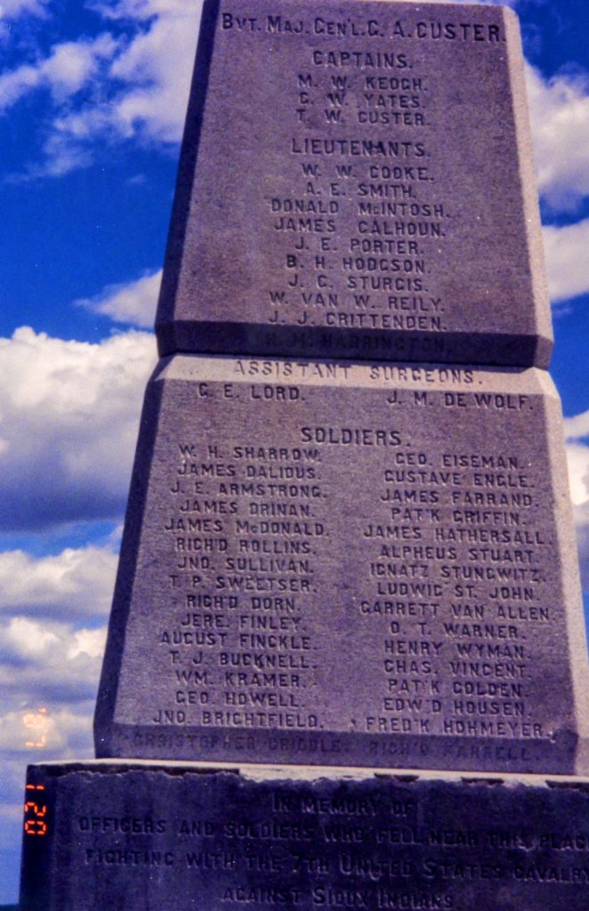
I’ve reached the Junction of 94E and 90E, and I’m staying on 90 East. The Little Big Horn Battlefield is the next right (55 miles away), and I’m compelled to stop even though I don’t have a ton of time. There is a lot of complicated history out here, and I can’t imagine driving by this site.
There’s just sky and land out here. Finally some trees appear, and I pass a little slough or marshy pond. But a few marks of society intrude on this peaceful land- a sign saying that Custer’s Last Stand re-enactment was June 20-22nd, and a little farm on my right with a shack and some horses.
It’s just after noon and I’m now on the Crow Indian Reservation. I pass the Big Horn River and there are real teepees on my left. I take the turnoff for Little Big Horn Battlefield Monument, which is the junction for the 212 East.

I park and walk around the Little Bighorn National Monument for about an hour.
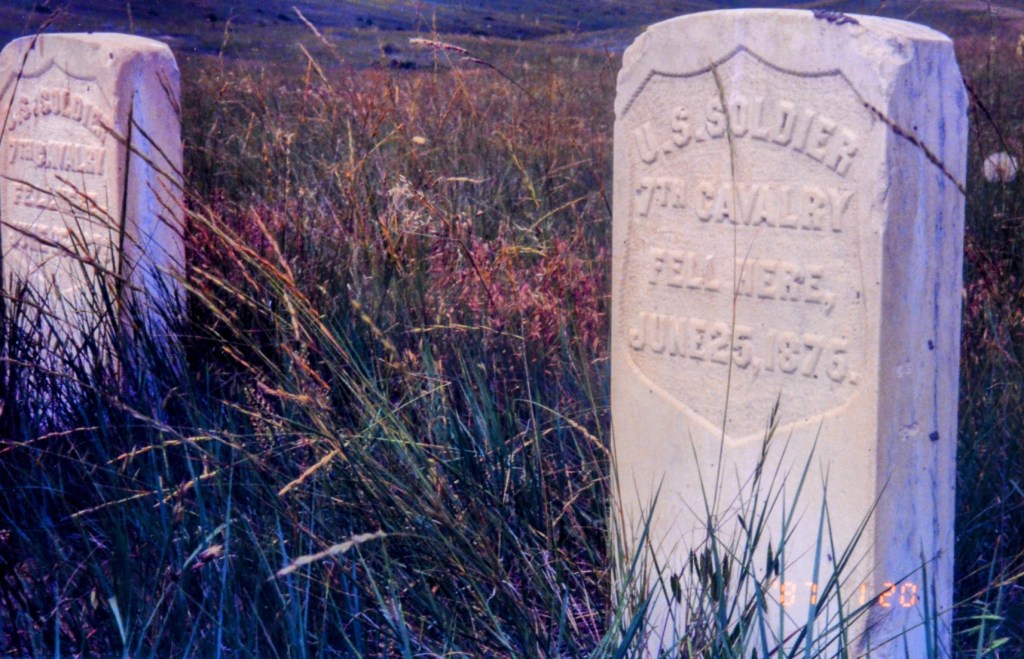
The battle took place June 25-26, 1876, so I just missed being here on the 127th anniversary. It made me think of Dances with Wolves, which, more than a decade ago, really brought alive the history and horror of what happened back then. Before that film, my only education had been things I had read and the rote history classes in high school that did not tell the truth.
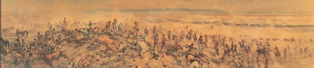
In the visitor’s center there’s a museum, artifacts, dioramas, and several paintings, including that one giant panoramic artwork called “After the Battle” by J.K. Ralston. That piece really moved me. To the left of the center foreground, there’s that native American woman who looks so haunted, and I think that describes the whole battlefield. I stood there mesmerized studying this piece for maybe fifteen or twenty minutes.
I then walk the trail up to the hill where Custer, along with many of his soldiers and Native Americans warriors, died. If you have some knowledge of the events of what happened, your mind can bring the history alive. It just requires you to use your imagination, reminding me of when I visited Gettysburg eight years ago; if you can, you tap into the energy of the place just standing there and its mesmerizing.


There is a quote on the wall in the visitor’s center by Black Elk that says, “Know the Power That is Peace”. I wish people today would heed that wisdom.

VISIONS OF CARY GRANT
Back on the 212 now going east, and the 50 mph limit speed limit is a bummer. The road is one lane in each direction, but there doesn’t seem to be many cars here. I see a sign that says 376 miles to Mt. Rushmore. I’m surrounded by rolling hills and a blue sky with enormous puffy clouds. All I had to eat today was a few swigs of Gatorade, a breakfast bar, and the free, burnt coffee in the hotel lobby that was barely palatable.
The cell phone still says “Searching For Service”, and I can’t imagine there are any towers to provide it here. For some reason I suddenly realize I need an oil change. The closest city is Belle Fourche (160 odd miles away), and I’ll scan for a place there.
I’m now on land owned by the North Cheyenne Indians, and I can see a few houses (one with a satellite dish), a basketball net, a teepee with holes in it, and wooden shacks that are army barrack style. There’s a cemetery on my right, and it makes me even more weary of passing trucks and cars on these one lane highways. It’s coming up to 2 o’clock as I enter Citizen Kane’s Rosebud County. The topography has changed from rolling plains to a forested area.
I figure if I went a direct route from Los Angeles, I’d probably be approaching NYC by now . . . but I’m still 300 miles from Mt. Rushmore as the car drops down a 6% grade hill. There are five more teepees on my left leading to rolling, tree dotted mountains. At Lame Deer I hit the brakes at a stop sign, but then it’s back up to 70 mph (the limit) right after that.
Crazy Head Springs is on my right as I zoom down a 7% grade for the next 2 miles. I curve to the left, then to the right, and continue a sinuous path up and then down. It’s such a treat to see this much open land. Living in L.A. for 5 years and before that Boston, you can’t turn around without seeing a building.
Now I’ve entered a big plain area, glimpsing mountains stretching out in the panorama far in the distance. It’s windy out here, making the tall grass ripple (looking like green water). After flattening off I’m heading down again (7% grade and popping ears), and there are more trees. A couple of cop cars buzz past me with their sirens blaring. It’s a naïve thought, but I don’t see how crime can exist out in such beautiful land. I cross the Tongue River and leave the North Cheyenne Indian Reservation.
I’m now in the town of Ashland, with its gas station, motels, ranger station for the national forest, discount fireworks stores, a club that has poker & pool, a bank, and charming wooden houses on my right and left. The electronic bank sign informs me that it’s 87 degrees. Passing Otter Creek, I’m directly behind a truck towing a horse carrier with no horse in it. A guy in a tractor hauls hay on my left, and the road goes up and down here. The pavement is wet, also very bumpy.
But with hardly any other travelers and beautiful scenery, 212 is a good highway. It’s hot in this car, though I can only crack the window because it’s extremely windy. Another reason to keep the window up- when big rigs pass, it sounds like Star Wars fighter planes buzzing each other and the wind rips through the car.
My stomach growls as I pass a patch of cows. Belle Fourche 124 miles away, and I’ll have to get something to eat there. There are mountains to the right off in the distance that almost look like pyramids. I’m at another crest, and from up here I see the road snake around all the way to the horizon at the top of the next hill. My ears are still popping.
Brodaus is 14 miles away, and I’m entering this giant cloud shadow that I could see up on the hill. I’m inside the patch of muted light for more than ten miles, and as I leave it, I feel as if I was trying to outrun some sort of spaceship. There are haystacks that remind me of Monet paintings on my right among rolling fields. Time to go down again and get that wonderful visibility for miles and miles.
I see a detour ahead, and the road is unpaved . . . my first dirt road on this trip. A strange sensation cruising along at 70 mph and being greeted by a hug pile of dirt. It seems like it goes on that way for a while, and a big rig just kicked up a dust storm. I was chewing gum and now I’m chewing dirt.
The undercarriage of my car just scraped the bottom of a big pot hole, and I can only imagine what it’s doing to my sad, old tires. After a few more miles of early 20th century driving, the road goes to the right and I’m back on the concrete of the 212 east. But wait, there’s more dust swirling in the air and there’s more road work, with loose gravel and 35 mph speed limit.
My car just took a beating, but it’s back to normal as a van with South Dakota plates passed me (I must be getting close to there). Okay, I’m going to attempt radio contact, the first time I’ve used this contraption since Oregon, or was it Idaho? I try the tape player, and there’s enough juice in the battery to get Jimmy Buffett singing if I keep the volume down low. The road has turned flat, and although I wouldn’t say it’s boring (how can it be with that sky), I just needed some music.
I’m registering my first signs of being fidgety, and I’m yearning for those giant craniums at Rushmore. I can’t help but think of Cary Grant in North by Northwest, the iconic Hitchcock film. I have another three or four days of traveling, and I need to reassess and look at the map. Maybe I should just go quick route, eliminating my excursion into North Dakota. I don’t have the money to stay in too many hotels and I made promises that I would be in Boston by July 2nd. This would be a perfect time for Jackson Browne’s “Running On Empty” album, but that stupid tape recorder ate it many states ago.
From a quick scan of the map while driving, Belle Fourche is in South Dakota and it’s 73 miles away. A billboard says, “He carved the Mountain. The Borglum Story”, and I must be getting close. I’m now in Hammond, and there’s a little café and a dilapidated shack. I see black spots on the road and worry about my eyes, but getting closer I see they’re birds and the black spots fly away. There is flatness all around, perfect grazing ground for the cows and sheep.

It’s nearly 4:00, and I’m 42 miles to South Dakota. The Buffett tape, even though I can barely hear it, is really helping on this long straightaway. I pass the Missouri River and the speed limit goes down to 50 as I read a billboard: “The Stoneville Saloon- cheap drinks and lousy food” and there’s a little cowgirl standing next to the letters. I’d love to stop but cannot.
The next sign is of more interest: Mt. Rushmore 130 miles. More cows. I don’t know why I feel compelled to keep noting the cows, maybe it has something to do with Danny DeVito and “Throw Mamma From The Train”. But the cow report continues with more of the animals revered by Hindus and Texans on that hill on the left. Are they sleeping? Are they dead? I’ve never seen cows in a recumbent position.
Off to my right are the first trees I’ve seen many miles, while on my left it’s still prairie land. I’m forced to slow down to 45 mph, and there’s a train on my right that runs parallel to the road. The Double T Ranch is on my left, and I glimpse a railcar turned over on its side that probably jackknifed a long time ago. A car passes me, and it’s the first vehicle I’ve seen in I don’t even know how many miles.
Hopefully the mountains off in the distance are the Black Hills where Mt. Rushmore is located. The odometer reads 120,382, and that means I’ve gone 3,000 miles since June 17th. That’s 10 days averaging 300 miles per, thought its much higher when you factor in the the days I spent in Seattle. A billboard declares: “The Belle Fourche Livestock Exchange, Howdy Folks.”
Just stopped at a store that I thought was a supermarket, hoping to appease my stomach, but it’s a department store with no food whatsoever. Belle Fourche is apparently the geographical center of the nation, and if I were so inclined I could see the exact spot if I drove north of the 85. But I’m locked into getting to Mount Rushmore.
It’s 4:43 pm, 75 degrees, and I haven’t had anything to eat today other than a breakfast bar. I’m finally in South Dakota, and as I travel through Main Street I stop at a chain for a steak and cheese sandwich. I’m such a hypocrite. I lament the proliferation of chains and detest them, but because I’m short on time I succumb to the fast-food familiar. I also know it will give me heartburn.
There are prairies on the right and left, but there are dark mountains straight ahead. They look as though they’re shadowed or even silhouetted, but in fact they are the famed Black Hills. Sporadic rain, big plops, hit my windshield. This is the first precipitation since entering Yellowstone.
The Black Hills are on my right, and there are storm clouds mixed in with blue skies on the left. I see signs for Wonderland Cave, Bethlehem Cave, The Crystal Cave (boasting the “least strenuous tour”) and Black Hills National Cemetery. And naturally, in such a historic and even sacred area, there are casinos. And there are also little chain hotels spattered on the landscape.
It’s 5:30 pm, and hopefully I can get to Rushmore by 7, stay there for 2hrs, and drive east until midnight. I’m getting close to the 16, which is the turn to Rushmore, and exit 57 looks to be what I’ll take from all the billboards advertising hotels and the like. The beauty of The Black Hills might be flanked by commercialism, but I can see that rainbow in the distance. I’m actually in South Dakota right now, and that’s a strange and wonderful feeling.
Finally I reach Highway 16, and it’s not quite six yet. The road is wet and goes down to one lane for some road work. I have to detour onto St. Joseph Street, and see the cool sign of the Hotel Alex Johnson. This town has a great vibe, with interesting architecture and a store that has a cowboy riding a bagel on its roof. There are some chains, but the historical buildings drown them out.
I’m now climbing, climbing, climbing.
Keystone is 20 miles away, Hill City is 26, but how far to Mt. Rushmore? I won’t be able to stay long, but I can’t wait to see it. A rainbow appears on my left. Don’t seem to be many people on this road, about six cars behind me, more coming in. I see an advertisement for “Cosmos Mystery Area Feel The force”, and can only assume it’s a tourist trap.
The road rises again, the sun blares right at me, and the car struggles forward. Rain falls on my left, but it’s nice and sunny here. I just crested the hill and I’m now going down. I’m officially in The Black Hills National Forest. The Mt. Rushmore exit is 2 miles away, 16A W, and we’re climbing again.
I drive underneath an old, wooden bridge, and it’s a curvy road down into the valley. I go through the mountain in a tunnel carved into it, and my ears are popping. A store in Keystone that has been charred from a fire is on the left, while the right side of the road sports homemade fudge, a covered wagon, and a Wax Museum. It’s up once more on a curvy hill, and it’s so bright I can’t see anything until the sign I’ve been waiting for: Mt. Rushmore National Park.
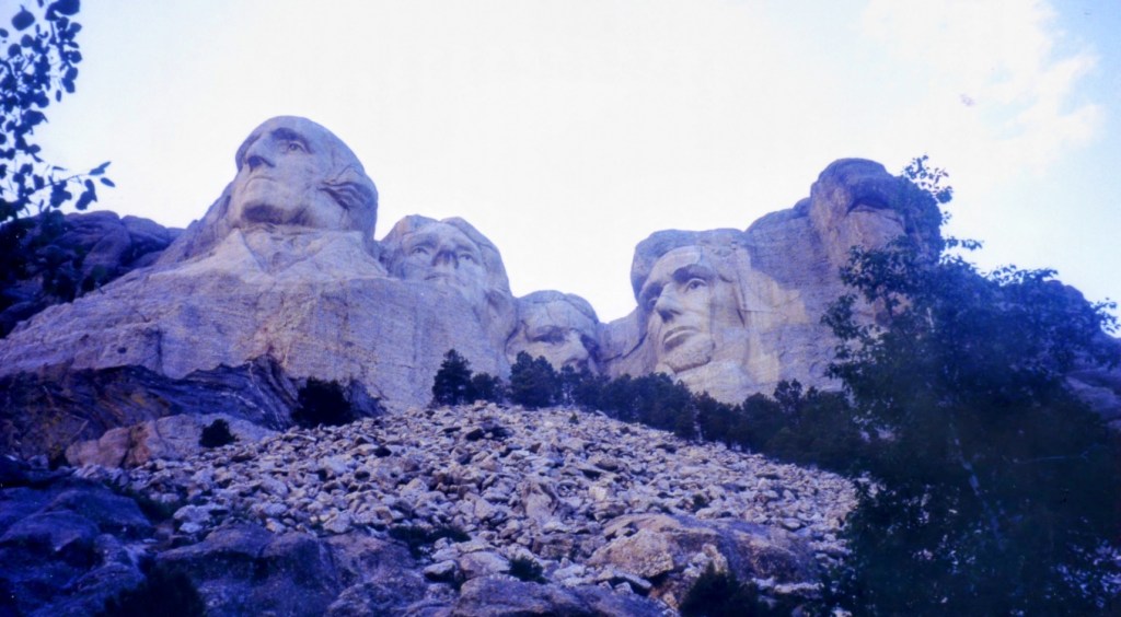

I park and walk around for over an hour, but now back in the car and time to leave.
My mind is still savoring the Rushmore experience as I navigate the Passat. Maybe it’s just chiseled rock, but I think it’s chiseled rock that everybody should see. It was astonishing, but now I must get back to Highway 90 and drive east as many miles as I can. If I had waited another 45 minutes I could have seen the light show, but missing it gives me a reason to go back.
I stop for gas ($26 at 1.65 a gallon) and I’m back on the freeway (or highway) at 9:30 pm. If I could drive for another 2 hours that would be fantastic. Though I don’t think I’ll get as far as Sioux Falls, if I could manage 140 miles that would put me within striking distance of Chicago for the next day.
I cleaned my windshield at the gas station, but the water must have been filthy because I’m getting a terrible glare now. It’s dark, I’m wearing my glasses (which weakens my already lackluster night vision), and whenever a car passes in the other direction, I can’t see anything. I must make a pit stop.
I’m not sure what town I’m in, but there’s a honkey-tonk saloon with music spilling onto the sidewalk about twenty-five yards ahead. I wipe down the windshield with a paper towel and bottled water, and decide to ditch the glasses. As I put on my contacts lenses, I get a weird “Thelma and Louise” vibe, as if some ranchers who’ve drank too much are going to attack me in this parking lot.
I quickly put the car in gear and get back on the dark and desolate 90 freeway. It’s ten o’clock, and I haven’t seen any signs for any towns. When there’s taillights to follow it’s not too bad, but I can’t keep up with these cars. I finally reach a place called Wasta, and there’s lot of construction as I cross the Cheyenne River. There’s a sign for the Badlands, which are 19 miles away.
Wall is the next town, and I’m exiting there.
It’s almost 10:30 pm and I can’t contend with the dark void of the road even with a clean windshield and contact lenses. I exit at Wall, Badlands (110), and begin to search for a hotel. Three places are sold out, but I get the last room (a smelly smoking one) at a rate that would be acceptable in midtown Manhattan. The only parking spot is a tiny space next to a concrete abutment, but I’m able to cram my car into it and squeeze out of the door.
Before going to my room I walk across the street to a gas station and buy a twelve pack of beer and some chips. Inside the hotel I locate the ice machine, take out three beers from the box, and fill it to keep it cold. I haven’t drank much alcohol on this trip, but I think this night will be the exception. The beer is needed.


Mr. Ostrowski! Jeepers, what a drive! Such l-o-n-g hours. I’d have not gone as far in a day as you did. But–hurrah! You made it to Mr. Rushmore (a place I have yet to see…). Like you at the end, I am exhausted. But I will be ready for the next installment when you get to it. CHEERS!
LikeLiked by 1 person
😊 Thanks, Shawn! It’s funny … when I think back to those long days of driving, I have no idea as to how I did it. But then I remember…I was 20 years younger. If I did the same trip now it would take me twice as long. 😂
LikeLike